Floods are a regular phenomenon in the world particularly in areas where the rainfall is seasonal as in South East and South Asia due to monsoon. Our rivers are basically glacier fed with level of glaciated waters heaviest in Indus and decreasing eastwards. Contrary to popular belief the rains provide only a part of river waters and in particular to the Indus. Heavy rains within a short span of a few days are the main contributory factor for the floods.
History speaks of wars, plagues, famines but not floods. The reason is very simple, that all cities and towns were on higher ground and whenever the floods came the people would take their belongings and livestock etc. to these high grounds and once the water went down after a few days, they would be back to their old livelihood. So the damage due to floods is basically a man-made phenomenon. The floods used to spread over a much larger area, refresh silt deposited to enrich the agricultural land and then recede back to their old routine within the established river course.
The main reasons for floods recurring are due to inexcusable failures of the governments to exercise their writ in any form. Massive deforestation has resulted in flash floods, cutting of jungles and shrubs from katcha areas has resulted in lack of retention of flood waters which used to get trapped in these jungles/shrubs. Massive growth of population even establishment of industry in the traditional river beds has further accentuated the problem.
The cutting down of jungles and forests and construction of dykes/embankments along both sides of Indus has had a negative effect. Now the entire silt is deposited within the river bed or at best in the katcha area. Over a period of last one century the Indus River bed has become higher than the surrounding land. Now the dykes/embankments have become a prerequisite due to this.
The taming of rivers for irrigation and other purposes is also one of the major reasons for causing devastation. The environmental impact of disturbance caused to a river system due to construction of dams or barrages has its own ecological price. The dams and barrages control the river by construction of embankments on both sides. The water which used to spread out and release its momentum, now stays within which adds to both the quantity and velocity of water i.e. the momentum. This water whenever it breaches these embankments causes maximum destruction.
The floods are classified as follows
Hundred Years Floods
This is one in a lifetime flood and 1929 flood in Indus was taken as a yard stick however both 2010 and 2014 floods have been no less. The scientists and engineers may have to redraw their parameters due to climate change etc. Exceptionally very high level flood warnings are increasing and recurring more often.
Five Years Floods
These recur more often and the quantum of floods is affected by the El-Nino and La-Nino factors. Normally high flood level warning is reached and the water does not cause outside the river bed or katcha areas.
Yearly Floods
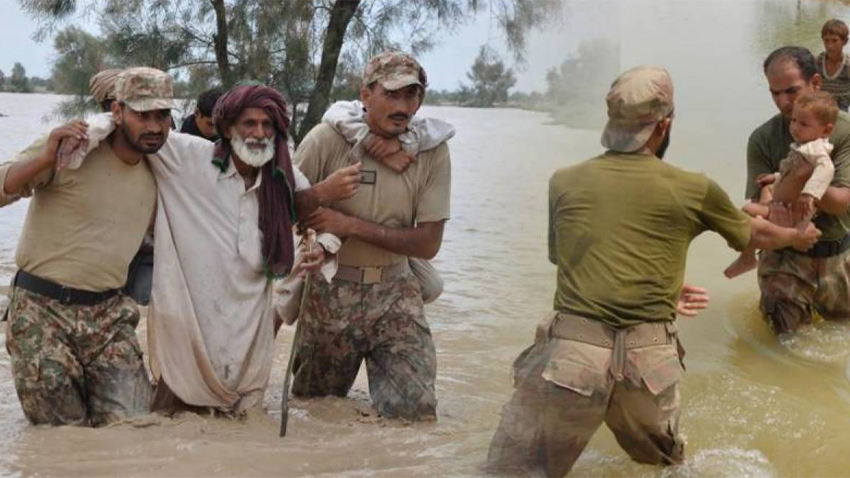
These recur every monsoon and the water level touches high flood level for a couple of days and then subsides. Sometimes the flood water is not enough even to fill the Tarbela and Mangla Dams. The damaged caused is insignificant only in the river course. Somehow the above parameters seem to be no more valid as Pakistan has had mega floods in 1973, 1976, In 1992 basically due to emptying of Tarbela Dam due to tunnel problem and more recently in 2010 and 2014.
Pakistan has a ready excuse to blame everything on India for releasing excessive water in Chenab and Jhelum, however this time Indian Held Kashmir was also severely affected by heavy rains and floods. It is understood that Indian authorities had informed GOP that approx. 1.2 million cusecs water was likely to come down from Akhnoor. This water was much beyond the retention capacity of both Sallal and Baglihar Dams. In reality the water that came to Pakistan was approx. 861,000 cusecs.
Very heavy rains in upper catchment areas of both Jhelum and Chenab was the main reason for floods this year further accentuated by political, non-technical and incompetent handling at all levels of the Govt.

Having studied the main reasons which cause floods lets analyze the countermeasures. There is definitely a requirement to take action in number of fields.
Water Diversion Projects
The excessive flood waters can be diverted conveniently to areas where it will not cause devastation and can even be helpful in re-invigorating the local hydrographic environment. The flood water escapes mentioned below will be controlled by regulators/spillways and take the water in a controlled manner to the desired areas.
- Ravi
Although it starts touching Pakistan border at Abial Dogran in Shakargarh then runs alongside international border and enters fully into Pakistan at Ravi Syphon upstream of Lahore.
(a) Regulator at BRB Syphon at Lahore
First place where a sizable quantity of flood waters can be diverted is as soon as it enters the borders, the excess water could be diverted into the Wagha Drain going all the way to Sutlej River. The drain needs to be dredged and widened and its capacity developed to carry at least upto 10,000 cusecs. It will also entail making a small regulator on Ravi at syphon.
(b) Balloki-Sulaimanki Link Canal
Its capacity to take water from River Ravi at Balloki to River Sutlej at Sulemanki can be increased further by dredging and increasing its width.
(c) Sidhnai-Mailsi Link Canal
In reality this starts from Chashma to Jhelum then from Rasul to Qadirabad, thence from Trimmu to Sidhnai and finally takes the Indus waters to Bahawalpur by syphoning across Sutlej River near Mailsi. A feasibility of using this system or enlarging its scope to be also utilized as a floods mitigating network should be undertaken to decide how much water can be diverted.
- River Chenab
The devastation carried out by this river has been maximum. It can be tamed to a large extent by either diverting some of its flood water through the link canals as mentioned above or construction of escapes to let the water flow into the un-inhabited areas of Thal desert.
a. Trimmu Escap
An escape to carry 50,000 cusecs of water from upstream of Trimmu Barrage to general area of thal can dissipate the strength of water to a large extent.
b. Muhammad Wala Bridge Escape
Another escape upstream of T-P link full into River Chenab again of approx. 50,000/-cusecs to let the water flow into Khudai Ranges will off set the flood danger to Multan and Muzaffargarh.
These escapes were already utilized in a functional manner by blowing up the dykes and allowing the water to go to lesser inhabited areas to save more heavily populated areas in the recent 2014 floods.

- River Sutlej
There areas number of places where River Sutlej flood waters had been diverted towards cholistan desert in the past. However there is no proper mechanism for this purpose:
1. Sulemanki Escape
Running from Sulemanki parallel to the borders can recharge the old Ghaggar/Hakra River bed.
2. Head Islam Escape
Water can be diverted to Tamewali area from Head Islam which is otherwise under-utilized due to provision of water to Bhawal canal from S&M Link Canal.
3. Mailsi Syphon Escape
This provides the shortest route to divert flood waters into Tamewali desert area.
4. Escapes can also be constructed to let off the flood waters into cholistan at Israni and a few more places.
- River Jhelum
This rivers flood waters are already very well regulated by the Mangla Dam and existence of Dal and Wular lakes in its upper reaches. The construction of Kishen Ganga and Neelum-Jhelum hydro-electric works followed by Kohala Dam will make this river even more manageable. It is only the man made decisions which can worsen and cause devastation as happened due to filling of the Mangla Dam in a very short period leaving no cushion for flood waters to be retained for a few days.
This river runs parallel to the Thal Desert from Khushab to its confluence with Chenab at Trimmu. A number of escapes can be made into the Thal Desert upto Trimmu to take the flood waters.
- River Indus
Like Jhelum it is also well regulated by the Tarbela Dam, Chashma barrage with capacity to hold. Again possibility of construction of 2 to 3 escapes from Chashma to Taunsa on its eastern bank to divert the flood waters into Thal desert should be examined. Early construction of Bhasha Dam and Dasu Dam will further increase the potential to regulate the river.
- Coordination Stream-lining
There is a need of achieving much better interaction with upper riparian states both Indian Punjab and IHK to get timely warnings. Water release particularly in Jhelum, Chenab and Ravi should be regulated by a joint mechanism by both countries as part of Indus Basin Treaty.
- Reafforestation
Massive reafforestation projects should be launched with the help of army, volunteers, boy scouts, and college students throughout the country particularly in the upper reaches of these rivers., The river bed or katcha areas to be properly defined and only forests to be allowed to grow there, these areas should be declared as reserve forest.
- Protection of River Bed
No population or industry should be permitted in katcha area/river bed. Sutlej and Ravi rivers have been literally reduced to the level of sewage water drains due to this population pressure.
- Moratorium on buildings more embankments/dykes. Let the flood waters spread out.
Conclusion
Numerous studies and comprehensive flood commission reports have been prepared over the last 60 years with the last one being Justice Mansoor Ali Khan’s Flood Commission Report on 2010 floods. It is time that we take cognizance of the floods menace and take timely actions. A five years plan to sort out all floodwater issues along with necessary capital works should be undertaken at the earliest. The following sums up the National Flood Control Strategy.
1. Better Coordination of all stake holders
2. Better Regulation of Flood Waters
3. Better Diversion of Flood Waters to Desired Area